Underground Utility Surveys
Full underground utility detection and mapping using Ground Penetrating Radar (GPR) and electromagnetic locators. Our PAS 128 compliant surveys prevent costly surprises during excavation, protecting your project timeline and budget.
Get a free quote- PAS 128 compliant data
- GPR scanning
- Electromagnetic location
- Utility mapping to CAD
- Depth estimation
- Service identification
- Risk assessment
- Combined topo-utility surveys
Preventing Costly Damage
Accidental damage to underground utilities can result in expensive repairs, project delays, safety hazards and potential prosecution. Our underground utility surveys use GPR and electromagnetic location equipment to detect and map buried services before you break ground.
We identify gas, electric, water, telecoms, drainage and fibre optic services, providing you with a clear picture of what lies beneath your site. This data is essential for safe excavation planning and forms a required part of most construction risk assessments.
PAS 128 Compliance
Our surveys comply with PAS 128, the published specification for underground utility detection, verification and location. The standard defines four quality levels:
- Quality Level D: desktop records search from utility providers
- Quality Level C: site reconnaissance to correlate visible features with records
- Quality Level B: detection using GPR and electromagnetic equipment (our standard survey level)
- Quality Level A: physical verification through trial holes
We deliver survey data classified to the appropriate quality level, giving you confidence in the accuracy and reliability of the information.
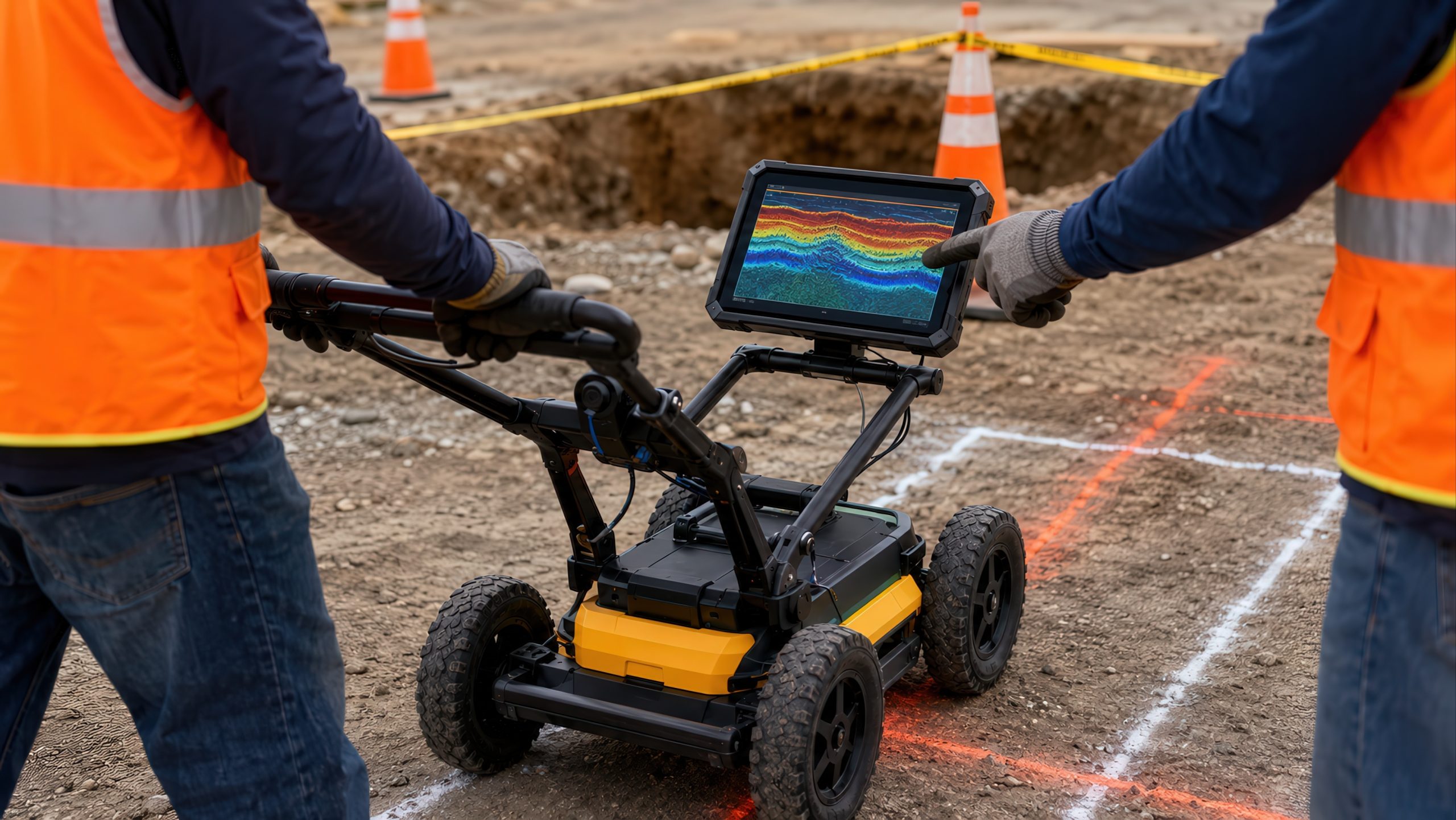
Our Detection Methods
We use a combination of detection techniques to maximise coverage:
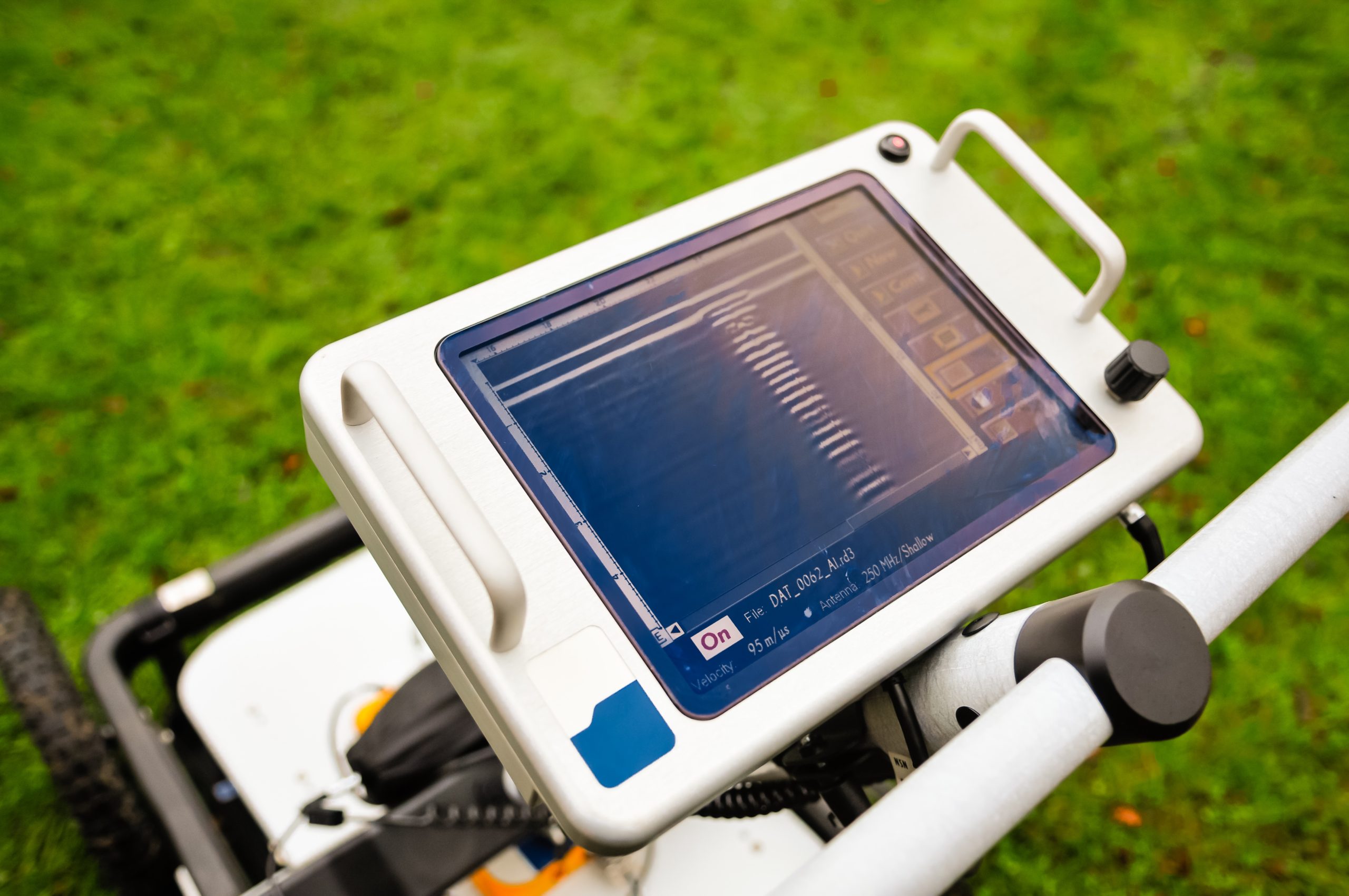
- Ground Penetrating Radar (GPR): detects both metallic and non-metallic services including plastic pipes, clay drains and fibre optic cables
- Electromagnetic locators (CAT and Genny): traces metallic pipes and cables with high accuracy
- Radio detection: picks up live signals from powered cables and telecoms
- Combined approach: overlapping techniques to minimise the risk of missed utilities
Integrated Survey Solutions
Underground utility surveys are most effective when combined with a topographical survey. We frequently deliver combined topo-utility survey packages that give you both the above-ground site context and below-ground utility data in a single coordinated dataset.
This integrated approach saves time, reduces cost and ensures the utility data is accurately positioned relative to surface features. All data is delivered in CAD format, fully layered and ready for use by your design team.
Detection Methods
Multiple techniques for maximum detection coverage
Ground Penetrating Radar
Detects metallic and non-metallic services including plastic pipes, clay drains and fibre optic cables.
Electromagnetic Location
CAT and Genny equipment traces metallic pipes and cables with high accuracy and depth estimation.
PAS 128 Compliance
All surveys delivered to PAS 128 standard with data classified to the appropriate quality level.
Combined Topo-Utility
Above-ground and below-ground data in one coordinated dataset, saving time and cost.
How We Deliver Your Survey
Consultation
We review your requirements, assess the site and provide a detailed quotation.
Site Survey
Our qualified surveyors visit the site with the latest equipment to capture accurate data.
Data Processing
Raw data is processed, quality-checked and prepared in your required format.
Delivery
Completed survey data delivered on time, with full support for any follow-up queries.
The Red Box Advantage
Calibrated Equipment
Professional-grade instruments maintained and calibrated for accurate, defensible results.
Expert Surveyors
90+ years combined experience. CSCS certified, fully insured and professionally qualified.
Fast Turnaround
Most surveys completed and delivered within 5-10 working days. Rush options available.
Fixed Pricing
Clear quotes upfront with no hidden fees. You know exactly what you pay before we start.
Fully Accredited
SSIP, CHAS, CSCS certified. Members of The Survey Association with full professional insurance.
UK-Wide Coverage
Nationwide service from our head office in Cheshire with satellite offices across the UK.
Why Choose Red Box Surveys
90+ Years Combined Experience
Our senior management team brings over 90 years of surveying experience, ensuring every project meets the highest standards.
Nationwide Coverage
With satellite offices across the UK, we deliver efficient, cost-effective services wherever your project is located.
Latest Technology
We use advanced 3D laser scanning, GPS and GPR equipment to deliver precise, reliable data every time.
Frequently Asked Questions
PAS 128 is the published specification for underground utility detection, verification and location. It defines four quality levels (A-D) for utility survey data, providing a standardised framework for specifying and commissioning utility surveys.
We use Ground Penetrating Radar (GPR) and electromagnetic locating equipment (CAT and Genny). GPR can detect both metallic and non-metallic utilities including plastic pipes, clay drains and fibre optic cables that electromagnetic methods can't find.
GPR can typically detect utilities to depths of 2-3 metres depending on ground conditions, soil type and the size of the utility. Electromagnetic locators can detect metallic services at greater depths. We always specify detection limitations in our reports.
We detect gas, electric, water, telecoms, drainage, fibre optics and other buried services. However, no detection method is 100% guaranteed. We use overlapping techniques to maximise detection rates and always recommend trial holes for critical areas.
A desktop utility study (PAS 128 Quality Level D) is recommended before an on-site survey. It provides existing utility records from all providers, giving our surveyors baseline information to work from. We can provide both services as a package.
Yes, and we'd recommend it. A combined topo-utility survey gives you both above-ground and below-ground data in one coordinated dataset, saving time and cost compared to commissioning them separately.
Get a free quote
Ready to discuss your project? Fill in the form and our team will get back to you with a detailed quotation, typically within 24 hours.