Visibility Splay & Speed Surveys
Expert visibility splay and speed surveys to ensure safe vehicular access and compliance with planning requirements. Our thorough approach includes precise measurements and assessments tailored to residential, commercial and infrastructure projects.
Get a free quote- Visibility splay drawings
- Speed survey data
- 85th percentile analysis
- Highway safety assessment
- Planning condition discharge
- Council-ready submissions
- Y-distance calculations
- Vegetation clearance reports

Safe Vehicular Access
A visibility splay survey is often required as part of a planning application when creating a new vehicular access or improving an existing one. Its primary purpose is to confirm that the proposed access point provides clear, unobstructed views for drivers entering or exiting the site.
To meet safety standards, existing boundary features such as walls, fences or hedges may need to be lowered, repositioned or removed. Our survey provides the data needed to make these decisions and satisfy planning conditions.
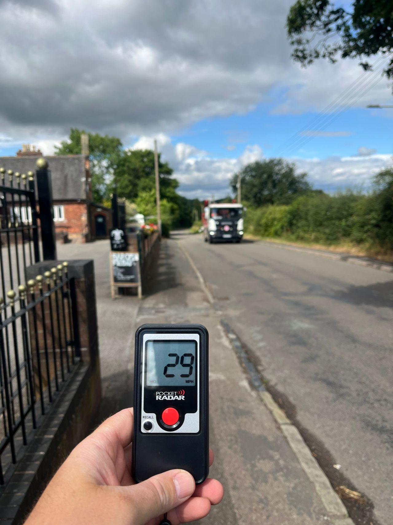
Speed Surveys and 85th Percentile
Speed surveys help determine the 85th percentile wet weather vehicle speeds, which is the speed at which 85% of traffic is travelling. This value is used to calculate appropriate visibility splay dimensions at junctions or access roads.
We conduct speed surveys using calibrated handheld directional speed guns, following the Department of Transport’s Technical Advice Note TA 22/81. Surveys are conducted in free-flowing conditions, outside peak times or areas where congestion may affect driver speed.

Meeting Planning Conditions
To meet planning conditions, a drawing should be produced showing the access and the visibility splays. This is submitted to the council as part of the “discharge of conditions” application. Once approved, the access must be constructed according to the approved plans.
Visibility splays are calculated by measuring along the edge of the main road (the “Y” distance) from a fixed point set back from the road edge (the “X” distance). The Y distance depends on the speed of traffic rather than volume.
Technical Details
How visibility splays and speed surveys work
Visibility Splay Calculation
Measured along the main road edge (Y distance) from a set-back point (X distance). Y depends on traffic speed.
85th Percentile Speed
The speed at which 85% of traffic travels, measured with calibrated speed guns following TA 22/81.
TA 22/81 Compliance
Speed surveys conducted following Department of Transport guidance in free-flowing conditions.
Planning Submissions
CAD drawings showing access and visibility splays ready for discharge of conditions applications.
How We Deliver Your Survey
Consultation
We review your requirements, assess the site and provide a detailed quotation.
Site Survey
Our qualified surveyors visit the site with the latest equipment to capture accurate data.
Data Processing
Raw data is processed, quality-checked and prepared in your required format.
Delivery
Completed survey data delivered on time, with full support for any follow-up queries.
The Red Box Advantage
Calibrated Equipment
Professional-grade instruments maintained and calibrated for accurate, defensible results.
Expert Surveyors
90+ years combined experience. CSCS certified, fully insured and professionally qualified.
Fast Turnaround
Most surveys completed and delivered within 5-10 working days. Rush options available.
Fixed Pricing
Clear quotes upfront with no hidden fees. You know exactly what you pay before we start.
Fully Accredited
SSIP, CHAS, CSCS certified. Members of The Survey Association with full professional insurance.
UK-Wide Coverage
Nationwide service from our head office in Cheshire with satellite offices across the UK.
Why Choose Red Box Surveys
90+ Years Combined Experience
Our senior management team brings over 90 years of surveying experience, ensuring every project meets the highest standards.
Nationwide Coverage
With satellite offices across the UK, we deliver efficient, cost-effective services wherever your project is located.
Latest Technology
We use advanced 3D laser scanning, GPS and GPR equipment to deliver precise, reliable data every time.
Frequently Asked Questions
A triangular area of land adjacent to a junction or access point that must be kept clear of obstructions to ensure drivers have adequate sight lines. The required dimensions depend on traffic speed and road type, calculated using the X and Y distance methodology.
The speed at which 85% of traffic is travelling, measured using calibrated speed guns following Department of Transport guidelines. This value provides a more accurate representation of typical traffic flow than average speed and is used to calculate visibility splay requirements.
Typically required as a planning condition when creating a new vehicular access or modifying an existing one. The survey demonstrates that adequate sight lines exist or can be achieved for safe entry and exit from the site.
We produce the drawings and supporting data ready for submission. The actual submission is usually handled by your planning consultant or architect, but we can liaise directly with the council if required.
Get a free quote
Ready to discuss your project? Fill in the form and our team will get back to you with a detailed quotation, typically within 24 hours.